-
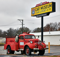 An old fire truck outside the Route 66 Car Museum in Springfield, Missouri, through which a portion of the historic two-lane road still zig and zag.
 The Route 66 Car Museum in Springfield, MO. There is a restored vintage fire-truck next to the signpost and the yellow sign reads “Car Museum”. A white building, trees, and power lines are visible in the background.
-
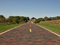 This stretch of hand-laid brick, completed as part of the once-grand U.S. Route 66 westward from Chicago to California, is preserved near the central-Illinois town of Auburn.
 An image of a hand laid brick road in Auburn, Illinois that was once part of Route 66. What appears to be a corn field is visible on the left side of the image. Grass can be seen on either side of the road and trees and a distant farm house are in the background.
-
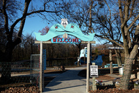 Kissing whales welcome visitors to the smiling Blue Whale of Catoosa roadside attraction in the small Oklahoma city of the same name.
 The entrance to a roadside attraction in the city of Catoosa, Oklahoma features two kissing blue whales above a wooden gate. A sign that reads “Welcome” is just below the whales, and an “Oklahoma US 66” sign is between the whale’s heads. A cement walkway leading to what appears to be a man made lake with a blue whale structure in it dominates the center of the photo. Leafless trees surround the area pictured.
-
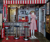 An old U.S. Route 66 cafe counter, reassembled at the Route 66 Motorheads Bar, Grill, and Museum outside Springfield, Illinois. The owner, Ron Metzger, has collected, restored, and displayed many artifacts from the historic, Chicago-to-California two-lane U.S. Route 66 over the years.
 A photo of a museum exhibit of a reassembled Route 66 diner/café counter. Steel counter stools with red and blue tops sit in front of a glass block counter. A pink waitress’ uniform and era typical signs for pay telephones, restrooms, and Coca Cola advertising can also be seen in the exhibit.
-
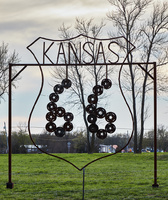 Roadside art in Baxter Springs, one of only two small towns (Galena is the other) in the ever-so-brief (just 11-mile) segment of historic U.S. Route 66 that's in Kansas.
 A metal folk art style sign that mimics the US Highway 66 signs that were used to designate route 66. The state in this version reads “Kansas”. Through the open form of the sign, trees and grass can be seen in the background. Indistinct buildings can also be seen.
-
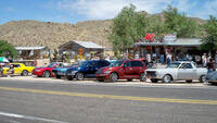 Members of the Canadian Route 66 Association, Hackberry General Store, Route 66 Fun Run, Hackberry, AZ. May 3, 2008.
 A photo of a group of cars belonging to members of the Canadian Route 66 association can be seen on the far side of the road in front of Hackberry General Store in Hackberry, AZ. The asphalt of Route 66 can be seen in the foreground. Desert mountains, trees, and other buildings can be seen in the background.
-
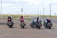 Swiss Bikers, Adrian, TX.
 An image of four motorcycles, each with a Swiss flag attached, are pulled off from Route 66 in Adrian, TX. Route 66 can be seen in the background of the image with grass, telephone poles, and other illegible signage behind.
-
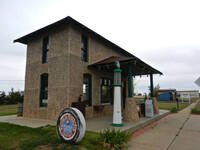 Restored Magnolia Gas Station, Route 66, Vega, TX
 Color image of a fully restored historic gas station on Route 66 in Vega, TX. A restored green and white vintage gas pump sits at the front of the building, and a round sign reads “Magnolia Petroleum Company”. There is grass beside and behind the gas station building. Other buildings can be seen in the background.
-
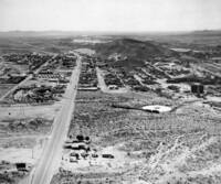 Aerial image of Barstow, CA, circa 1940 looking west. Note Santa Fe Railway yard and engine houses on right. Route 66 runs west towards Victorville through the image.
 A black and white image shows an aerial view of Barstow, CA in the early 1940s. Route 66 runs through the center of the image. Hills can be seen in the distant background and buildings of various types are seen in the foreground and middle of the photo.
-
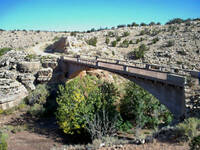 Padre Canyon Bridge which carried the first alignment of Route 66 from 1926-32.
 An image of an old, concrete bridge spanning a dry riverbed in Arizona. Vegetation from the riverbed is overgrown and is nearly touching the bottom of the bridge. Rocks and pale hills can be seen in the background with a blue sky above.
-
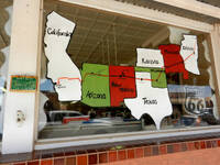 Route 66 map on window of store, 2nd Street and Kinsley Street, Winslow, AZ. Arizona
 A multi-colored window paining on the front window of a store in Winslow, AZ showing the states that Route 66 runs through. A reflection of a black and white Route 66 sing can also be seen.
-
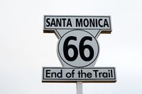 Sign: "Santa Monica 66, End of the Trail" at the Santa Monica Pier in Santa Monica, California
 A close up image of a black and white road sign on the Santa Monica Pier in Santa Monica, CA. The sign reads “Santa Monica 66 End of the Trail”.
-
 Traveling Route 66
 A video providing a brief synopsis of the history and cultural impact of Route 66. The video makes note of the impact of the road is allowing farm workers to travel out of the Dust Bowl to look for work in California.
-
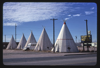 Wigwam Village #6, Route 66, Holbrook, Arizona
 White teepee shaped buildings sit in a row behind a black sign with yellow writing that reads “Wigwam Village”. A white vehicle can be seen between the structures. A clear blue sky with wispy clouds stretches overhead.
-
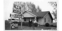 Julia Chaney interview - Julia Chaney and house at 66 Motel
 A woman in a skirt suit stands between a building and signage for a motel. The sings read “66 Motel Modern”, “Heated Cabins, Clean and Reasonable”, and “Vacancy”. Another sign advertises a price of $2.00 (USD).
-
 Garage, Route 66 mural in Needles, California.
 An image of a mural painted on a garage door in Needles, California. The garage door is painted with the image of a red, Model-T type of car with a mechanic inspecting it and tool boxes in the background. There is a hand painted Route 66 sign next to the image depicted in the mural.
-
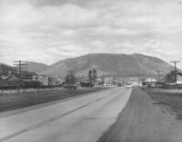 West end of Route 66 leading into Flagstaff, Arizona; Saginaw Manistee Lumber Company at left, Arizona Lumber and Timber Company office building on right, Elden Mountain in background, 1950.
 A black and white photograph showing Route 66 as it appeared in Flagstaff, Arizona in 1950. Lumber company mills can be seen in the foreground, with Elden Mountain in the background behind the lumber operations.
-
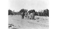 Workers at the site of U.S. Highway Route 66 construction; James Maddox is second from the left, 1926
 A black and white image of five workers who were to begin construction on the new Route 66 stretch in northern Arizona
-
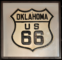 US 66 route marker
 A black and white highway sign states “Oklahoma, US 66”. This sign would have been placed on posts along Route 66 through the state of Oklahoma to notify drivers which road they were taking.
-
 Abandoned cars, Route 66, Arizona.
 An image of abandoned cars that have rusted out behind a signpost with a faded Route 66 marker at the top. Various hand painted signs point in different directions on the signpost below the Route 66 marker. A backdrop of mountains can be seen far in the distance.
 An old fire truck outside the Route 66 Car Museum in Springfield, Missouri, through which a portion of the historic two-lane road still zig and zag. The Route 66 Car Museum in Springfield, MO. There is a restored vintage fire-truck next to the signpost and the yellow sign reads “Car Museum”. A white building, trees, and power lines are visible in the background.
 This stretch of hand-laid brick, completed as part of the once-grand U.S. Route 66 westward from Chicago to California, is preserved near the central-Illinois town of Auburn. An image of a hand laid brick road in Auburn, Illinois that was once part of Route 66. What appears to be a corn field is visible on the left side of the image. Grass can be seen on either side of the road and trees and a distant farm house are in the background.
 Kissing whales welcome visitors to the smiling Blue Whale of Catoosa roadside attraction in the small Oklahoma city of the same name. The entrance to a roadside attraction in the city of Catoosa, Oklahoma features two kissing blue whales above a wooden gate. A sign that reads “Welcome” is just below the whales, and an “Oklahoma US 66” sign is between the whale’s heads. A cement walkway leading to what appears to be a man made lake with a blue whale structure in it dominates the center of the photo. Leafless trees surround the area pictured.
 An old U.S. Route 66 cafe counter, reassembled at the Route 66 Motorheads Bar, Grill, and Museum outside Springfield, Illinois. The owner, Ron Metzger, has collected, restored, and displayed many artifacts from the historic, Chicago-to-California two-lane U.S. Route 66 over the years. A photo of a museum exhibit of a reassembled Route 66 diner/café counter. Steel counter stools with red and blue tops sit in front of a glass block counter. A pink waitress’ uniform and era typical signs for pay telephones, restrooms, and Coca Cola advertising can also be seen in the exhibit.
 Roadside art in Baxter Springs, one of only two small towns (Galena is the other) in the ever-so-brief (just 11-mile) segment of historic U.S. Route 66 that's in Kansas. A metal folk art style sign that mimics the US Highway 66 signs that were used to designate route 66. The state in this version reads “Kansas”. Through the open form of the sign, trees and grass can be seen in the background. Indistinct buildings can also be seen.
 Members of the Canadian Route 66 Association, Hackberry General Store, Route 66 Fun Run, Hackberry, AZ. May 3, 2008. A photo of a group of cars belonging to members of the Canadian Route 66 association can be seen on the far side of the road in front of Hackberry General Store in Hackberry, AZ. The asphalt of Route 66 can be seen in the foreground. Desert mountains, trees, and other buildings can be seen in the background.
 Swiss Bikers, Adrian, TX. An image of four motorcycles, each with a Swiss flag attached, are pulled off from Route 66 in Adrian, TX. Route 66 can be seen in the background of the image with grass, telephone poles, and other illegible signage behind.
 Restored Magnolia Gas Station, Route 66, Vega, TX Color image of a fully restored historic gas station on Route 66 in Vega, TX. A restored green and white vintage gas pump sits at the front of the building, and a round sign reads “Magnolia Petroleum Company”. There is grass beside and behind the gas station building. Other buildings can be seen in the background.
 Aerial image of Barstow, CA, circa 1940 looking west. Note Santa Fe Railway yard and engine houses on right. Route 66 runs west towards Victorville through the image. A black and white image shows an aerial view of Barstow, CA in the early 1940s. Route 66 runs through the center of the image. Hills can be seen in the distant background and buildings of various types are seen in the foreground and middle of the photo.
 Padre Canyon Bridge which carried the first alignment of Route 66 from 1926-32. An image of an old, concrete bridge spanning a dry riverbed in Arizona. Vegetation from the riverbed is overgrown and is nearly touching the bottom of the bridge. Rocks and pale hills can be seen in the background with a blue sky above.
 Route 66 map on window of store, 2nd Street and Kinsley Street, Winslow, AZ. Arizona A multi-colored window paining on the front window of a store in Winslow, AZ showing the states that Route 66 runs through. A reflection of a black and white Route 66 sing can also be seen.
 Sign: "Santa Monica 66, End of the Trail" at the Santa Monica Pier in Santa Monica, California A close up image of a black and white road sign on the Santa Monica Pier in Santa Monica, CA. The sign reads “Santa Monica 66 End of the Trail”.
 Traveling Route 66 A video providing a brief synopsis of the history and cultural impact of Route 66. The video makes note of the impact of the road is allowing farm workers to travel out of the Dust Bowl to look for work in California.
 Wigwam Village #6, Route 66, Holbrook, Arizona White teepee shaped buildings sit in a row behind a black sign with yellow writing that reads “Wigwam Village”. A white vehicle can be seen between the structures. A clear blue sky with wispy clouds stretches overhead.
 Julia Chaney interview - Julia Chaney and house at 66 Motel A woman in a skirt suit stands between a building and signage for a motel. The sings read “66 Motel Modern”, “Heated Cabins, Clean and Reasonable”, and “Vacancy”. Another sign advertises a price of $2.00 (USD).
 Garage, Route 66 mural in Needles, California. An image of a mural painted on a garage door in Needles, California. The garage door is painted with the image of a red, Model-T type of car with a mechanic inspecting it and tool boxes in the background. There is a hand painted Route 66 sign next to the image depicted in the mural.
 West end of Route 66 leading into Flagstaff, Arizona; Saginaw Manistee Lumber Company at left, Arizona Lumber and Timber Company office building on right, Elden Mountain in background, 1950. A black and white photograph showing Route 66 as it appeared in Flagstaff, Arizona in 1950. Lumber company mills can be seen in the foreground, with Elden Mountain in the background behind the lumber operations.
 Workers at the site of U.S. Highway Route 66 construction; James Maddox is second from the left, 1926 A black and white image of five workers who were to begin construction on the new Route 66 stretch in northern Arizona
 US 66 route marker A black and white highway sign states “Oklahoma, US 66”. This sign would have been placed on posts along Route 66 through the state of Oklahoma to notify drivers which road they were taking.
 Abandoned cars, Route 66, Arizona. An image of abandoned cars that have rusted out behind a signpost with a faded Route 66 marker at the top. Various hand painted signs point in different directions on the signpost below the Route 66 marker. A backdrop of mountains can be seen far in the distance.