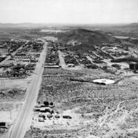
Aerial image of Barstow, CA, circa 1940 looking west. Note Santa Fe Railway yard and engine houses on right. Route 66 runs west towards Victorville through the image.
Item
- Title
- Aerial image of Barstow, CA, circa 1940 looking west. Note Santa Fe Railway yard and engine houses on right. Route 66 runs west towards Victorville through the image.
- Rights
- NAU Cline Library Digital Archives. Reproduction requires permission of the repository. Permission granted in fall 2021.
- Creator
- Clark, H.A. (unknown)
- Date
- 1940-1943 C.E.
- Description
- A black and white image shows an aerial view of Barstow, CA in the early 1940s. Route 66 runs through the center of the image. Hills can be seen in the distant background and buildings of various types are seen in the foreground and middle of the photo.
- Format
- Gelatin Silver print (black and white). 3.5x4.5 inches.
- Publisher
- Northern Arizona University Cline Library Digital Archives.
- Contributor
- Cyrena Hoaglund
- Identifier
- Northern Arizona University Cline Library Digital Archives. NAU.PH.94.34.14.
- Subject
- Travel; history; American history; Route 66; Barstow; car; California; historic roads; preservation.
- Source
- Tiff file. Northern Arizona University Cline Library Digital Archives. 11/09/21.
- https://cdm16748.contentdm.oclc.org/digital/collection/cpa/id/12523/rec/1
- Item sets
- Route 66 Through the Decades
- Site pages
- Postwar Changes